

-
Personalized issue. Glorious United Kingdom
Great Britain 2008
In issue: Sheet(s): 1
Printing: on self-adhesive paper
Issued in: sheets of 20 (4x5) stamps with different labels
-
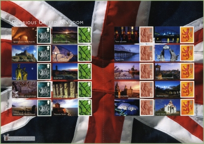
Perforation type: 14 ¾x14
Subject:
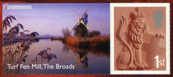
The sheet contained 4 types of definitive stamps and 20 various labels with the most well-known places of the United Kingdom.
On 13-th label - the Wind pomp of the Turf Fen* on the river Ant, The Boards National park.***Additional:
*Turf Fen drainage mill was built by Yarmouth millwright, William Rust c.1875 to drain Horning marshes into the River Ant and is thus similar in design to High's_mill at Potter Heigham. Although the tower only had two floors, it was 31' high with a Norfolk style boat shaped cap, four double shuttered sails of seven bays and a six bladed fantail. This mill, very unusually, has a double scoop wheel with a choice of high or low gears.
The mill ceased working around the 1920s when cattle no longer grazed the marshes.
This mill is on the river Ant in Irstead**. The water levels around the mill are now kept very high and there is no footpath or land access to the mill. The mill can be seen by boat from the river Ant or from How Hill on the Ludham side of the river.
1976: Norfolk Windmills Trust took over responsibility for the mill and set about major restoration project
1986: Mill returned to pristine condition and fitted with a new cap and new sails
February 2007: New wood paddles fitted to the scoop wheel by trainee millwrights
Information has been taken on Norfolk mills site
** Irstead is a village in The Broads National Park in the English county of Norfolk, England. The village is situated at Irstead Shoals, on the River Ant just south of Barton Broad, the second largest of the Norfolk Broads. The village forms part of the civil parish of Barton Turf, and the district of North Norfolk
***The Broads is a network of mostly navigable rivers and lakes (known locally as broads) in the English counties of Norfolk and Suffolk. The Broads, and some surrounding land was constituted as a special area with a level of protection similar to a UK National Park by The Norfolk and Suffolk Broads Act of 1988. The Broads Authority, a Special Statutory Authority responsible for managing the area, became operational in 1989.
The total area is 303 km² (188 sq. miles), most of which is in Norfolk, with over 200 km (125 miles) of navigable waterways. There are seven rivers and sixty three broads, mostly less than twelve feet deep. Thirteen broads are generally open to navigation, with a further three having navigable channels. Some broads have navigation restrictions imposed on them in autumn and winter.
Although the terms Norfolk Broads and Suffolk Broads are used to identify those areas within the two counties respectively, the whole area is sometimes referred to as the "Norfolk Broads". The Broads has the same status as the national parks in England and Wales but as well as the Broads Authority having powers and duties almost identical to the national parks it is also the third largest inland navigation authority. Because of its navigation role the Broads Authority was established under its own legislation on 1 April 1989. More recently the Authority wanted to change the name of the area to The Broads National Park in recognition of the fact that the status of the area is equivalent to the rest of the national park family but was unable to get agreement from all the different parties. The Private Bill the Authority is promoting through Parliament is largely about improving public safety on the water and the Authority did not want to delay or jeopardise these provisions for the name issue, so the provision was dropped before the Bill was deposited in Parliament.Size (of sheet, booklet) mm: 297x210
Topics: Mills within the landscapes Personalized stamps Wind pumps and farm windmill