

-
Millennium. Part 3: Urban transformations
New Zealand 1998.11.11
In issue: Stamp(s): 6
Printing: lithography
-
Number by catalogue: Michel: 1730 Yvert: 1659 Scott: 1558
Perforation type: 14x14 ¼
Subject:
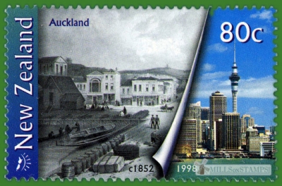
80 cents. Transformations of the city of Auckland*, in two photos of 1852 and 1998.
Additional:
*The Auckland metropolitan area, in the North Island of New Zealand, is the largest and most populous urban area in the country with over 1.4 million residents, 31 percent of the country's population. Demographic trends indicate that it will continue to grow faster than the rest of the country. Increasingly cosmopolitan, Auckland also has the largest Polynesian population of any city in the world, and has seen many people of Asian ethnicity move there in the last two decades.
The metropolitan area is made up of Auckland City (excluding the Hauraki Gulf islands), North Shore City, the urban parts of Waitakere and Manukau cities, and Papakura District and some urban parts of Rodney and Franklin Districts. In Māori its name is Tāmaki-makau-rau, or the transliterated version of Auckland, Ākarana.
Auckland lies between the Hauraki Gulf of the Pacific Ocean to the east, the low Hunua Ranges to the south-east, the Manukau Harbour to the south-west, and the Waitakere Ranges and smaller ranges to the west and north-west. The central part of the urban area occupies a narrow isthmus between the Manukau Harbour on the Tasman Sea and the Waitemata Harbour on the Pacific Ocean. It is one of the few cities in the world to have harbours on two separate major bodies of water.______
The photo of 1852 used on stamp, well shows an arrangement of a known mill for that moment:
Topics: Mills within the landscapes Windmills
-
Africa
- Algeria ⁄ 2
- Ascension Island ⁄ 1
- Cameroon ⁄ 1
- Cape Verde ⁄ 2
- Central African Republic ⁄ 1
- Ciskei ⁄ 1
- Cote d'Ivoire ⁄ 1
- Egypt ⁄ 1
- Equatorial Guinea ⁄ 1
- Ethiopia ⁄ 1
- Fernando Pó ⁄ 1
- Gambia, The ⁄ 1
- Ghana ⁄ 3
- Lesotho ⁄ 2
- Liberia ⁄ 1
- Mauritius ⁄ 1
- Mayotte ⁄ 1
- Morocco ⁄ 8
- Namibia ⁄ 2
- Niger ⁄ 1
- Reunion ⁄ 1
- Senegal ⁄ 1
- Seychelles ⁄ 1
- Somalia ⁄ 1
- South Africa ⁄ 7
- South West Africa, SWA ⁄ 1
- Spanish Sahara ⁄ 1
- Tanzania ⁄ 2
- Transkei ⁄ 1
- Tunisia ⁄ 2
- Uganda ⁄ 2 America
- Anguilla ⁄ 2
- Antigua and Barbuda ⁄ 2
- Argentina ⁄ 4
- Aruba ⁄ 5
- Barbados ⁄ 4
- Bolivia ⁄ 1
- Brazil ⁄ 2
- British Antarctic Territory ⁄ 2
- British Virgin Islands ⁄ 1
- Canada ⁄ 5
- Chile ⁄ 4
- Costa Rica ⁄ 2
- Cuba ⁄ 1
- Curacao ⁄ 2
- Dominican Republic ⁄ 1
- Ecuador ⁄ 1
- Guyana ⁄ 1
- Jamaica ⁄ 1
- Mexico ⁄ 1
- Montserrat ⁄ 1
- Mustique island ⁄ 1
- Netherlands Antilles ⁄ 7
- Paraguay ⁄ 2
- Peru ⁄ 2
- Saint Vincent and the Grenadines ⁄ 3
- Saint Vincent and the Grenadines, Union Island ⁄ 1
- Suriname ⁄ 2
- Turks and Caicos Islands ⁄ 2
- United Nations. New York ⁄ 2
- United States of America ⁄ 6
- Uruguay ⁄ 9 Asia
- Aden ⁄ 1
- Armenia ⁄ 1
- Azerbaijan ⁄ 9
- Bahrain ⁄ 11
- Bangladesh ⁄ 1
- China, People's Republic of ⁄ 3
- Georgia ⁄ 1
- Hong Kong ⁄ 4
- India ⁄ 3
- Indonesia ⁄ 2
- Israel ⁄ 11
- Japan ⁄ 11
- Kazakhstan ⁄ 3
- Korea, North ⁄ 5
- Korea, South ⁄ 5
- Laos ⁄ 1
- Macau ⁄ 6
- Malaysia ⁄ 4
- Mongolia ⁄ 1
- Mountainous Karabakh, Republic of ⁄ 1
- Philippines ⁄ 2
- Singapore ⁄ 4
- South Arabia (Hadhramaut) ⁄ 1
- Sri Lanka ⁄ 2
- Taiwan ⁄ 7
- Tajikistan ⁄ 1
- Turkey ⁄ 5
- United Arab Emirates ⁄ 1
- Vietnam ⁄ 1 Europe
- Alands ⁄ 12
- Albania ⁄ 3
- Alderney ⁄ 1
- Austria ⁄ 13
- Belarus ⁄ 14
- Belgium ⁄ 17
- Bosnia and Herzegovina. Croatian Adm. ⁄ 2
- Bosnia and Herzegovina. Muslim Adm. ⁄ 5
- Bulgaria ⁄ 4
- Croatia ⁄ 2
- Cyprus ⁄ 4
- Czech Republic ⁄ 12
- Czechoslovakia ⁄ 17
- DDR ⁄ 5
- Denmark ⁄ 20
- Estonia ⁄ 7
- Faroe Islands ⁄ 3
- Finland ⁄ 5
- France ⁄ 25
- French Andorra ⁄ 4
- Germany ⁄ 8
- Germany. The Soviet occupation ⁄ 1
- Gibraltar ⁄ 2
- Great Britain ⁄ 20
- Greece ⁄ 17
- Guernsey ⁄ 5
- Hungary ⁄ 5
- Iceland ⁄ 2
- Ireland ⁄ 2
- Isle of Man ⁄ 21
- Italy ⁄ 1
- Jersey ⁄ 11
- Kosovo ⁄ 1
- Latvia ⁄ 3
- Liechtenstein ⁄ 8
- Lithuania ⁄ 4
- Luxembourg ⁄ 8
- Macedonia, Republic of ⁄ 1
- Malta ⁄ 11
- Moldova ⁄ 2
- Monaco ⁄ 8
- Montenegro ⁄ 1
- Netherlands ⁄ 51
- Northern Cyprus ⁄ 2
- Norway ⁄ 2
- Poland ⁄ 9
- Portugal ⁄ 14
- Portugal. Acores ⁄ 7
- Portugal. Madeira ⁄ 3
- Romania ⁄ 12
- Russia ⁄ 5
- San Marino ⁄ 5
- Serbia ⁄ 2
- Slovakia ⁄ 7
- Slovenia ⁄ 12
- Sovereign Military Order of Malta ⁄ 6
- Spain ⁄ 28
- Spanish Andorra ⁄ 2
- Sweden ⁄ 20
- Switzerland ⁄ 6
- Ukraine ⁄ 20
- United Nations. Geneve ⁄ 3
- USSR ⁄ 11
- Vatican City ⁄ 2
- Yugoslavia ⁄ 6 Oceania
- Australia ⁄ 12
- Marshall Islands ⁄ 1
- New Caledonia ⁄ 3
- New Zealand ⁄ 6
- Norfolk Island ⁄ 1
- Palau ⁄ 1
- Papua New Guinea ⁄ 1
- Ross Dependency ⁄ 1
- Tonga ⁄ 2
- Wallis and Futuna ⁄ 4
- 2020 ⁄ 19
- 2019 ⁄ 17
- 2018 ⁄ 25
- 2017 ⁄ 20
- 2016 ⁄ 60
- 2015 ⁄ 14
- 2014 ⁄ 15
- 2013 ⁄ 19
- 2012 ⁄ 21
- 2011 ⁄ 31
- 2010 ⁄ 33
- 2009 ⁄ 38
- 2008 ⁄ 32
- 2007 ⁄ 26
- 2006 ⁄ 35
- 2005 ⁄ 22
- 2004 ⁄ 21
- 2003 ⁄ 12
- 2002 ⁄ 24
- 2001 ⁄ 19
- 2000 ⁄ 14
- 1999 ⁄ 17
- 1998 ⁄ 8
- 1997 ⁄ 14
- 1996 ⁄ 5
- 1995 ⁄ 7
- 1994 ⁄ 9
- 1993 ⁄ 10
- 1992 ⁄ 6
- 1991 ⁄ 4
- 1990 ⁄ 10
- 1989 ⁄ 11
- 1988 ⁄ 4
- 1987 ⁄ 11
- 1986 ⁄ 9
- 1985 ⁄ 8
- 1984 ⁄ 6
- 1983 ⁄ 9
- 1982 ⁄ 7
- 1981 ⁄ 7
- 1980 ⁄ 10
- 1979 ⁄ 6
- 1978 ⁄ 7
- 1977 ⁄ 4
- 1976 ⁄ 8
- 1975 ⁄ 9
- 1974 ⁄ 3
- 1973 ⁄ 8
- 1972 ⁄ 3
- 1971 ⁄ 5
- 1970 ⁄ 6
- 1969 ⁄ 4
- 1968 ⁄ 5
- 1967 ⁄ 8
- 1966 ⁄ 1
- 1965 ⁄ 2
- 1964 ⁄ 2
- 1963 ⁄ 2
- 1962 ⁄ 3
- 1961 ⁄ 5
- 1960 ⁄ 3
- 1959 ⁄ 2
- 1958 ⁄ 2
- 1957 ⁄ 4
- 1955 ⁄ 3
- 1954 ⁄ 2
- 1953 ⁄ 3
- 1951 ⁄ 3
- 1949 ⁄ 1
- 1947 ⁄ 1
- 1946 ⁄ 3
- 1945 ⁄ 1
- 1944 ⁄ 3
- 1943 ⁄ 1
- 1942 ⁄ 2
- 1939 ⁄ 2
- 1938 ⁄ 1
- 1937 ⁄ 1
- 1936 ⁄ 1
- 1934 ⁄ 1
- 1932 ⁄ 1
- 1923 ⁄ 1
- 1921 ⁄ 1
- 1920 ⁄ 1
- 1916 ⁄ 1
- Alphonse Daudet ⁄ 5
- Cattle mills ⁄ 9
- Children's toys ⁄ 8
- Don Quijote ⁄ 32
- Hydroelectricity ⁄ 30
- Industrial mills ⁄ 29
- Irrigation and water wheels ⁄ 54
- Manual and Kitchen mills ⁄ 30
- Miguel de Cervantes Saavedra ⁄ 24
- Mills in Art ⁄ 151
- Mills within the landscapes ⁄ 197
- Mortars and grinding stones ⁄ 21
- Olive oil and wine mills ⁄ 8
- Personalized stamps ⁄ 2
- Stylized mills ⁄ 146
- Sugar and salt mills ⁄ 21
- Various ⁄ 140
- Watermills ⁄ 219
- Wind pumps and farm windmill ⁄ 102
- Wind turbines ⁄ 259
- Windmills ⁄ 510