

-
Issue for the benefit of the National Tourist Association (ANVV)
Netherlands 1932.05.23
In issue: Stamp(s): 4
-
1932-s-logo.jpg)
Number by catalogue: Michel: 249 Yvert: 241 Scott: B54
Perforation type: 12 ½x12 ½
Subject:
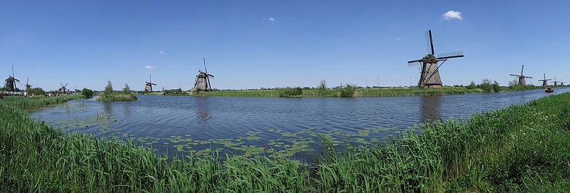
2 1/2 (+1 1/2) guldens. A silhouette of a windmill (wind pump) on a background of a polders**and similar mills in Kinderdijk*
Additional:
*Kinderdijk is a village in the Netherlands, partly in the municipality Nieuw-Lekkerland, partly in the municipality of Alblasserdam, in the province South Holland, about 15km east of Rotterdam.
Kinderdijk is situated in a polder at the confluence of the Lek and Noord rivers. To drain the polder, a system of 19 windmills was built around 1740. This group of mills is the largest concentration of old windmills in the Netherlands.
The windmills of Kinderdijk are one of the best known Dutch tourist sites. They were placed on the list of UNESCO list of World Heritage Sites in 1997.The name Kinderdijk is Dutch for "Child's Dike". In 1421 during the Saint Elizabeth flood of 1421, the Grote Hollandse Waard flooded, but the Alblasserwaard polder stayed unflooded. It is said that when the terrible storm had subsided, someone went on to the dike between these two areas, to see what could be saved. He saw in the distance a wooden cradle floating. There was no hope that anything would be living in it, but when it approached, movement was seen. When the cradle came nearer, someone saw that a cat was in the cradle trying to keep it in balance by jumping back and forth so that no water could come into it. When the cradle eventually came near the dike, someone fished the cradle out and saw that in it a baby slept quiet and dry. In some of the stories the cat kept it balanced and afloat. This folktale and legend has been published as "The Cat and the Cradle" in English (Meder 2007; Griffis, 1918).
Modern view of Kinderdijk (thw picture if from Wikimedia)
**A polder is a low-lying tract of land enclosed by embankments known as dikes, that forms an artificial hydrological entity, meaning it has no connection with outside water other than through manually-operated devices. There are three types of polder:
Land reclaimed from a body of water, such as a lake or the sea bed.
Flood plains separated from the sea or river by a dike.
Marshes separated from the surrounding water by a dike and consequently drained.
The ground level in drained marshes subsides over time and thus all polders will eventually be below the surrounding water level some or all of the time. Water enters the low-lying polder through ground swell due to water pressure on ground water or rain fall and transportation of water by rivers and canals. This usually means that the polder has an excess of water that needs to be pumped out or drained by opening sluices at low tide. However, care must be taken in not setting the internal water level too low. Polder land made up of peat (former marshland) will show accelerated compression due to the peat decomposing in dry conditions.
Polders are at risk from flooding at all times and care must be taken to protect the surrounding dikes. Dikes are mostly built using locally available materials and each has its own risk factor: sand is prone to collapse due to oversaturation by water while dry peat is lighter than water, making the barrier potentially unstable in very dry seasons. Some animals dig tunnels in the barrier, undermining the structure; the muskrat is notorious for this behavior. For this reason in the Netherlands it is actively hunted to extinction. No such care is taken in neighboring Germany though, causing the stock to be constantly resupplied across the border.
Polders are most commonly found, though not exclusively so, in river deltas, former fen lands and coastal areas.Topics: Mills within the landscapes Wind pumps and farm windmill Windmills